This is a level 5 number, measurement, and geometry activity from the Figure It Out theme series.


Click on the image to enlarge it. Click again to close. Download PDF (463 KB)
calculate rates of speed
convert between nautical miles and metres
use scales on maps to find distances
follow instructions of compass degrees and scale distances
FIO, Levels 3-4, Theme: Sport, Sailing with Maths, pages 18-19
A protractor, a ruler, a sharp pencil
Square grid paper
A calculator
Students should find this sailing activity interesting, especially as it involves the scenario of an actual America’s Cup course.
In calculating the length of the course in question 1, encourage the students to use multiplication rather than repeated addition. The total length of the course can be easily found by multiplying the total distance in nautical miles (3 nm x 6 plus 0.5 nm for the extra distance to the committee boat at the start and finish of the race) by 1 852 metres. The students may find other ways of working this out correctly.
Calculations with speed are quite difficult, and the students will need some help in finding solutions to question 2. Scaffolding questions such as these will help:
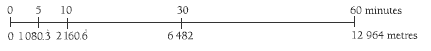
“How far does a boat travelling at 1 knot travel in 1 hour?” (1 852 metres)
“How far is that in a minute?” (1 852 ÷ 60 = 30.86 metres)
“How far is that in 5 minutes?” (30.86 x 5 = 154.3 metres)
“If that is the distance for a boat travelling at 1 knot, how far would a yacht travelling at 7 knots go in 5 minutes?” (154.3 x 7 = 1080.3 m)
This could be shown as a double number line:
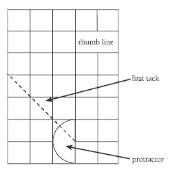
For question 3, the students will need to use the scale and the measurements given on the course map to draw the course on square grid paper.
For question 4, ensure that the students know how to measure tacking at 45° using their protractor and grid paper.
They also need to realise for question 4c that the tacking course that they plot is as efficient as possible, that is, it is as short as possible but does not have the yacht turning too often, as this will slow it down. They can discuss these points when they compare their course with a classmate’s.
Points about speed and tacking when sailing downwind are given in the Answers.
Answers to Activity
1. 34 262 metres (18.5 nautical miles)
2. 1 080.333 metres
3.–4. Teacher to check. The first part of your drawing should look like this:
5. The yacht would travel faster, and there would be less need for tacking with the wind behind the yacht. The yacht might make only one tack on a downwind leg compared with several on an upwind leg.